
The latest headlines from our reporters across the US sent straight to your inbox each weekday
Your briefing on the latest headlines from across the US
Hurricane Beryl has made landfall in the United States, after reaching the coast of Matagorda, Texas around 4am CDT Monday morning, and is now traversing inland across eastern Texas.
Tropical storm Beryl intensified into a Category 1 hurricane before it reached land in the early hours, causing hundreds of thousands of Texan customers to lose power within hours of Beryl arriving at the coast.
The National Hurricane Center has warned of heavy rainfall, strong winds and life-threatening storm surge to batter areas of Texas today.
The hurricane is hurtling inland with maximum sustained winds of 80mph (130km/h) and is currently around 85 miles (135km) south-southwest of Houston, Texas, the NHC said.
More than a million people in Texas were placed under a hurricane warning, with Acting Texas Governor Dan Patrick declaring 120 counties to be disaster areas ahead of the storm and warned Beryl “will be a deadly storm”.
School systems, airports and major oil shipping operations have been suspended and will remain closed for the day on Monday.
Beryl has already left a trail of destruction as a Category 5 hurricane through Mexico and the Caribbean.
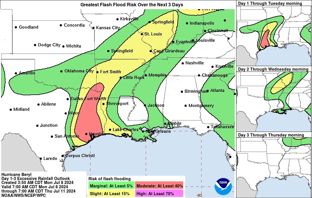
Heavy rainfall battering areas of Texas, with some reaching up to 15 inches
Heavy rainfall of five to 10 inches, with localized amounts of 15 inches, is expected across portions of the middle and upper Texas Gulf Coast and eastern Texas today into tonight, the National Hurricane Center states.
Considerable flash and urban flooding, as well as minor to isolated major river flooding, is also expected.
“Extremely heavy rainfall will move northward this morning with areas of flash flooding likely,” the Weather Prediction Center said Monday morning. “This will include areas of considerable to severe urban flash flooding with locally life-threatening impacts expected.”
“Some of the major metropolitan areas including the Houston/Galveston vicinity will be at particular risk over the next several hours,” they added.
As Beryl continues to traverse inland, portions of far southeastern Oklahoma, Arkansas and southern Missouri are also predicted to experience three to five inches of heavy rainfall tonight into Tuesday.
As for other possible weather events, the NHC warns that a few tornadoes may occur tonight along the upper Texas Coast, and several tornadoes are possible today across parts of east Texas, Louisiana, and Arkansas.
Surf swells brought on by Beryl are expected to affect eastern Mexico and much of the Gulf Coast of the US during the next day or two, which can cause life-threatening surf and rip current conditions.
Storm surge, strong winds, urban and flash flooding: What to be aware of as Beryl makes landfall
At 4am on Monday, Hurricane Beryl made landfall near Matagorda, Texas with max winds sustaining at 80mph.
The National Hurricane Center warns of a continuing danger of life-threatening storm surge inundation along the coast of Texas from Mesquite Bay to Sabine Pass, including Matagorda Bay and Galveston Bay.
People residing in those areas should follow all advice from local authorities, the NHC said.
Hurricane-force winds have also been brought by Beryl to portions of Texas this morning, and considerable flash and urban flooding is expected today into tonight across areas of the middle and upper Texas Gulf Coast and eastern Texas.
Minor to isolated major river flooding has also been predicted.
The weather experts also warn of life-threatening beach conditions brought on by rip currents through Tuesday across much of the Gulf Coast, with beachgoers advised to heed warning flags and advice of lifeguards or officials before going in the water.
Galveston shuts down public facilities ahead of Beryl
Galveston announced on Sunday it will close all of its public facilities to prepare for the arrival of Tropical Storm Beryl, which is expected to make landfall as a Category 1 hurricane in southeast Texas on Monday morning.
“Out of an abundance of caution, City facilities will be closed on Monday and only essential personnel will report to work,” the city said in a Facebook post. “The recreation centers, public buildings, municipal court, and City Hall will all be closed Monday.”
The closures will not affect police, fire and emergency services, according to the city. Public work crews addressing storm-related infrastructure will also still be operating.
The city said that public buildings should re-open on Tuesday.
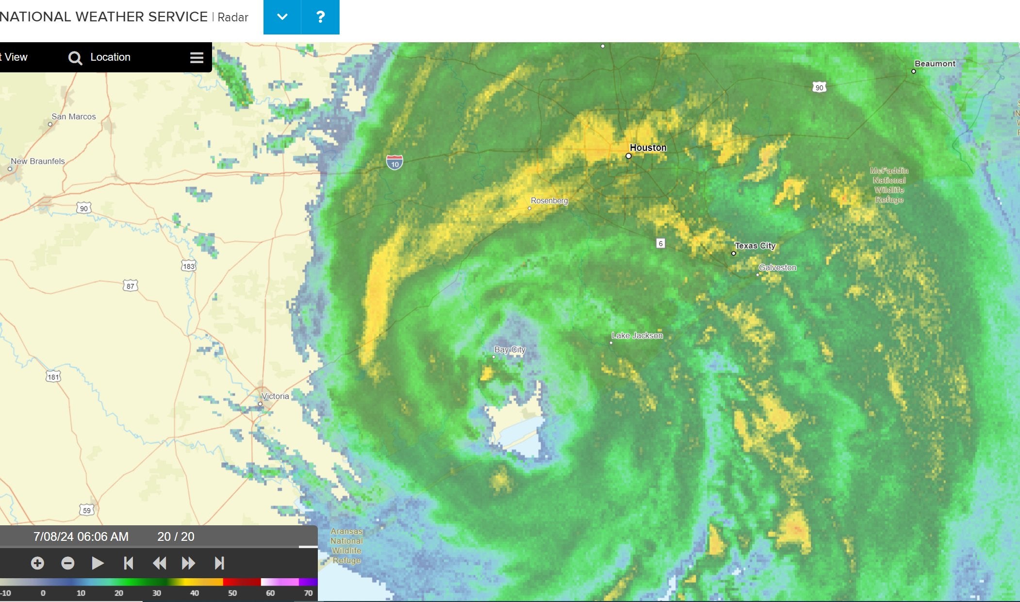
Beryl moving over eastern Texas an hour after landfall
Hurricane Beryl is moving inland over eastern Texas, with heavy rainfall battering the region.
Beryl is now 70 miles (115km) south-southwest of Houston, Texas as of 5am CDT, and is currently producing life-threatening storm surge and heavy rainfall across portions of Texas.
Damaging winds are hammering the coast of Texas, with strong winds also moving inland.
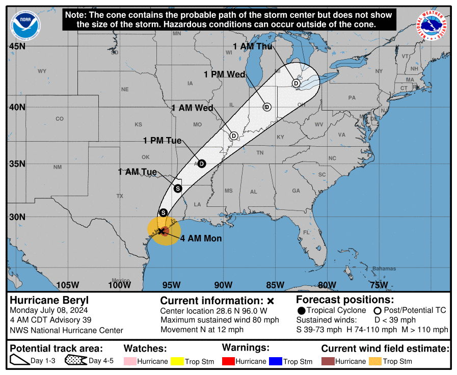
Where will Beryl go now it has made landfall?
Hurricane Beryl has made landfall in the middle of the Texas coast Monday morning, bringing with it maximum sustained winds of 80mph.
Now that Beryl has reached the United States, the National Hurricane Center expects the center of Beryl to move over eastern Texas today before moving through the Lower Mississippi Valley into the Ohio Valley on Tuesday and Wednesday.
However, as Beryl makes its journey, the weather experts predict that the Hurricane will experience steady to rapid weakening as the center moves inland.
With that, Beryl is expected to weaken into a tropical storm later today and then into a tropical depression on Tuesday.
Over 199,000 experiencing power outages in Texas
As Hurricane Beryl made landfall early Monday morning, an estimated 199,295 customers in Texas were experiencing some form of power outage as of 5.56am ET, according to poweroutage.us, however, this number could potentially keep on increasing.
In Matagorda, where Beryl made landfall around 4am, over 12,000 Texans are currency without power.
The neighboring coastal county of Brazoria currently has over 21,000 with their power out.
The number of people experiencing power outages and disturbances is rapidly increasing by the minute as Hurricane Beryl moves inland in The Lone Star State.
Weather experts and Texas acting governor warn Texans ahead of landfall
A multitude of warnings have been delivered to residents of Texas before Hurricane Beryl made landfall on Monday morning along the Texas coast.
A Hurricane Warning is currently in place for the Texas coast from Mesquite Bay northward to Port Bolivar, and a Tropical Storm Warning has been given to the Texas coast north of Port Bolivar to Sabine Pass.
The National Hurricane Center (NHC) has been cautioning about the severity of storm surge in the area, meaning there is a “danger of life-threatening inundation” from rising water moving inland from the coastline.
A Storm Surge Warning is in effect for Mesquite Bay to Sabine Pass, including Matagorda Bay and Galveston Bay.
The NHC is urging people located within these areas to take action to protect life and property from the rising water and to follow any potential evacuation and all other instructions from local officials.
The NHC says that water could reach the following heights above ground somewhere in the indicated areas if the peak surge occurs at the time of high tide:
Port O’Connor, TX to San Luis Pass, TX: 4-7 ft
Matagorda Bay: 4-7 ft
San Luis Pass, TX to High Island, TX: 4-6 ft
Galveston Bay: 4-6 ft
Mesquite Bay, TX to Port O’Connor, TX: 3-5 ft
High Island, TX to Sabine Pass, TX: 3-5 ft
The deepest water will occur along the immediate coast near and to the right of the center. The surge could also bring large and destructive waves and potential flooding.
“Residents sheltering in place should take precautions right away for sustained wind, heavy rain, flooding, storm surges on the coast, and possible tornados,” Acting Texas Governor Dan Patrick said on Sunday.
“It is of utmost importance that Texans pay close attention to their local officials. As Acting Governor, I am in constant communication with state agencies and will continue to do so. Do not ignore this very serious storm.”
The centre of Beryl has made landfall near Matagorda, Texas
The center of Bery has made landfall near Matagorda, Texas, the National Hurricane Center said at 4am CDT Monday morning.
Beryl’s maximum sustained winds have remained at 80mph (130km/h), meaning that it has made landfall as a Category 1 Hurricane.
Beryl is currently 85 miles (135km) south-southwest of Houston, Texas.
Watch Live: View of downtown Houston as Hurricane Beryl bears down on Texas
Beryl is expected to make landfall along middle Texas coast within next hour or two
Beryl is forecast to make landfall as a hurricane along the middle Texas coast during the next hour or two as the storm draws near.
After strengthening back into a Category 1 hurricane, Beryl is packing maximum sustained winds of 80mph (130km/h) as it approaches the middle Texas coast.
In the National Hurricane Center’s 3am CDT update, Beryl was around 15 miles (25km) south-southeast of Matagorda, Texas.
Matagorda City recently reported a sustained wind of 68 mph (109 km/h) and a gust of 86 mph (139 km/h).
“Life-threatening storm surge and heavy rainfall is ongoing across portions of Texas,” the National Hurricane Center has warned. “Sustained tropical-storm-force winds and hurricane-force wind gust have already been reported along the coast, these winds will continue to spread inland.
Source: independent.co.uk