
For free real time breaking news alerts sent straight to your inbox sign up to our breaking news emails
Sign up to our free breaking news emails
Sign up to our free breaking news emails
A tornado warning has been issued ahead of the arrival of Storm Eowyn set to batter UK’s coasts with 100mph winds this weekend.
The Met Office issued a rare red warning across Northern Ireland and Scotland which will see winds rapidly during the Friday morning rush hour with peak gusts of 80-90 mph fairly widely and perhaps up to 100 mph along some exposed coasts.
The forecaster said: “This brings the risk of significant disruption to transport and power supplies, as well as dangerous conditions outdoors.”
All schools in Northern Ireland have been advised to close on Friday, Stormont’s Education Minister Paul Givan has said.
It came as Irish premier Simon Harris urged people to stay away from the coast with the storm expected to strike at midnight. He said: “Storm Eowyn is dangerous, destructive and damaging.
“We cannot give a higher warning than nationwide red. The risk to life is extreme and real.”
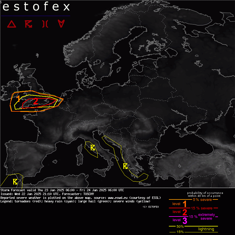
It came as the European Storm Forecast Experiment published a map putting southern England under a level 2 tornado warning for severe wind gusts with a few tornado events possible. They said: “a strong event cannot be ruled out”.
All Northern Irish schools to close on Friday
All schools in Northern Ireland have been advised to close on Friday amid a rare red warning for wind issued for Storm Eowyn, Stormont’s Education Minister Paul Givan has said.
“I understand this will impact on the work of schools and indeed on other businesses and services, but the decision has been taken to avoid any potential risk to life for children and young people as well as staff,” he said.
“Schools should put plans in place today for remote learning so that pupils can study at home.”
Across the Irish border Met Eireann has issued a rare nationwide red warning for wind across the Republic of Ireland, describing possible “danger to life”.
Extreme risk to life during Storm Eowyn – Irish premier Simon Harris
There is an “extreme” risk to life during Storm Eowyn, Irish premier Simon Harris has said.
Mr Harris said he had been briefed on the storm approaching Ireland from midnight.
Amid a nationwide red weather warning, he said: “Storm Eowyn is dangerous, destructive and damaging.
“We cannot give a higher warning than nationwide red. The risk to life is extreme and real.
“You need to pay attention. Do not travel. Do not go near the sea.”
New weather map reveals strong and damaging winds in Northern Ireland
‘Small chance of isolated tornado today’ – Met Office
A Met Office spokeswoman told The Independent: “There is a small chance of an isolated tornado today (23 Jan 2025) as a squally front moves eastwards, primarily Wales and central and/or southern parts of England, but the chance in any one location is very low.
“Most areas will just experience a period of heavy rain and gusty winds, perhaps with some hail and thunder in places, before it clears to the North Sea during the afternoon.
“A Yellow warning for wind is in force for southern England and parts of Wales until 6pm today.
“Around 30 tornadoes a year are reported in the UK but here in the UK we do not ‘warn’ for tornado’s as they do in countries like the USA as these are typically small and short-lived, but can cause structural damage if they pass over built-up areas.”
Met Office issues rare red warning with 100mph winds to strike coastal areas
The forecaster warned that very strong winds associated with Storm Éowyn causing very dangerous conditions with widespread disruption over Northern Ireland.
They urged people to watch out for:
- Flying debris resulting in danger to life
- Large waves and beach material being thrown onto coastal roads, sea fronts and homes
- Very dangerous driving conditions with fallen trees on roads
- Power cuts affecting other services, such as mobile phone coverage
- Damage to buildings and homes, with roofs blown off and power lines brought down
- Roads, bridges and railway lines closed, with delays and cancellations to bus, train, ferry services and flights
Red warnings across Ireland
The Republic of Ireland’s forecasting agency has issued a Status Red wind warnings for 22 counties from Dublin, to Louth, Cork, Galway and Donegal from the early hours of Friday – with some schools set to close.
Status Orange wind warnings are also in place for counties in the south east.
Met Eireann said: “Gale force southerly winds becoming westerly will bring severe, damaging and destructive winds with gusts of up to 130kmh (80mph) widely, with even higher gusts for a time.”
The expected impacts include fallen trees, damage to power lines and power outages, structural damage, very difficult travelling conditions, disruption and cancellations to transport, and wave overtopping.
Status Red is the highest level wind warning issued by the agency and is due to predicted “destructive gusts in excess of 130kmh”. Met Eireann said this brings a “danger to life” and “extremely dangerous” travelling conditions.
Storm Eowyn: Rail, road, sea and air travel disrupted as Met Office weather warnings come into effect
Storm Eowyn (pronounced “ay-oh-win”) is forecast to bring strong winds to much of the UK on Friday and into Saturday. The latest bout of severe winter weather is already causing travel disruption, with rail firms cancelling some trains on Friday – one is warning passengers not to travel north of York.
Simon Calder, Travel Correspondent of The Independent, has been surveying the likely damage to travel plans.
European Storm Forecast Experiment issue tornado warning for next 24 hours
A level two alert has been issued by the European Storm Forecast Experiment, warning of the possibility of “severe wind gusts with a few tornado events possible” in the south of England on Thursday.
A spokesman said: “A ESFE A level 2 was issued for S UK mainly for severe wind gusts with a few tornado events possible. A strong event cannot be ruled out. “A level 1 surrounds the level 2 area with a similar risk but lower probabilities.”
Where and when snow and 90mph winds will hit UK after Met Office weather warnings issued
Weather map shows likely advance of Storm Eowyn
Source: independent.co.uk